The population and housing forecast for the Perth - Inner region
Read forecast analysis and insights for the Perth - Inner region from Australia's largest independent population forecasting team.
Detailed forecasts are available for this region
Our premium services give you detailed forecast information for this region to help you invest in the right place, at the right time.
- Forecasts by age and sex
- Single-year forecast periods
- Custom local area geography
- Forecasts of housing and development
Menu
Read the insights and analysis behind our population and dwellings forecasts for the Perth - Inner region.
About the Perth - Inner region
Including the Central Business District of Greater Perth, and stretching north of the Swan River and west to the Indian Ocean, Perth - Inner consists of :
- The City of Perth, The City of Vincent, parts of the Cities of Bayswater and Stirling, The Town of Cambridge, The City of Subiaco, The City of Nedlands, The Town of Claremont, The Town of Cottesloe, The Shire of Peppermint Grove and the Town of Mosman Park.
- The radial Perth commuter rail network is centred on Perth Railway station (and the Perth Underground Railway station), and major highways such as the Graham Farmer Freeway, Stirling Highway and Mitchell Freeway pass through the region.
- Unlike the other metropolitan Perth SA4s, the Perth-Inner region includes mainly of more densely populated inner city suburbs and established middle ring suburbs with no greenfield development. Significant redevelopment plans are in place for East Perth and Subiaco, and densification is being directed across the major arterial routes of the SA4.
- This SA4 region is home many of the key government, commercial and recreation sites of the State, including the State Parliament and Supreme Court, headquarters of large companies, the WACA and Kings Park.
Key findings
Brownfields redevelopment and densification: Perth - Inner region's population and dwelling growth
The Perth - Inner region's population and dwelling growth has three features. Firstly, there are individual site redevelopments such as Riverside in East Perth and Subi Centro/Subi East and the Subiaco Activity Centre Plan in Subiaco-Shenton Park that will drive significant population growth. Secondly, the major highways and arterial roads in the regional are assumed to be a focus of higher density and mixed use buildings, while the remaining areas are assumed to have modest growth, or small amounts of infill. Over the forecast period, Perth - Inner is expected to grow from 87,160 to 116,207 dwellings, an additional 29,000 dwellings by 2046, with the population increasing from 188, 872 to 250, 147 over the same period, an increase of 61,275 people.
The largest proportion of population growth at a local level belongs to a cluster of SA2's in and around the CBD, namely Perth (West) - Northbridge, Perth (North) - Highgate and East Perth as well as the Subiaco - Shenton Park SA2, contributing 10,483, 5,814, 7,079 and 11,083 additional persons respectively. This growth is attributed to the significant number of additional residential dwellings, particularly apartments, identified within these areas over the forecast period. A significant number of dwellings identified are in large brownfield redevelopment sites.
Outside of these major developments, within the City of Vincent, growth is expected along the main transport corridors, as well as in the Mount Hawthorn - Leederville SA2 where the Leederville Town Centre will concentrate higher density residential development. Within the City of Perth in the Perth (West) - Northbridge SA2 construction at the Elizabeth Quay development is underway with approximately 900 additional dwellings expected to be completed over the next few years.
Mount Hawthorn - Leederville SA2 is forecast to experience the most infill development in the 25 years to 2046, although at a relatively modest quantum, adding an additional 196 dwellings.
None of the SA2s that make up Perth - Inner will lose population.
About the Perth - Inner region
Including the Central Business District of Greater Perth, and stretching north of the Swan River and west to the Indian Ocean, Perth - Inner consists of :
- The City of Perth, The City of Vincent, parts of the Cities of Bayswater and Stirling, The Town of Cambridge, The City of Subiaco, The City of Nedlands, The Town of Claremont, The Town of Cottesloe, The Shire of Peppermint Grove and the Town of Mosman Park.
- The radial Perth commuter rail network is centred on Perth Railway station (and the Perth Underground Railway station), and major highways such as the Graham Farmer Freeway, Stirling Highway and Mitchell Freeway pass through the region.
- Unlike the other metropolitan Perth SA4s, the Perth-Inner region mainly includes more densely populated inner city suburbs and established middle ring suburbs with no greenfield development. Significant redevelopment plans are in place for East Perth and Subiaco, and densification is being directed across the major arterial routes of the SA4.
- This SA4 region is home many of the key government, commercial and recreation sites of the State, including the State Parliament and Supreme Court, headquarters of large companies, the WACA and Kings Park.
| 2026 | 2031 | 2036 | 2041 | 2046 | |
|---|---|---|---|---|---|
Forecast population |
201,408 |
213,836 |
226,154 |
238,102 |
250,146 |
Change (five year) |
12,536 |
12,428 |
12,318 |
11,948 |
12,044 |
Average annual change (%) |
1.29% |
1.20% |
1.13% |
1.03% |
0.99% |
Forecast dwellings |
92,000 |
98,827 |
104,740 |
110,468 |
116,207 |
Change (five year) |
4,840 |
6,827 |
5,913 |
5,728 |
5,739 |
Average annual change (%) |
1.09% |
1.44% |
1.17% |
1.07% |
1.02% |
What share of Australia's growth will occur in Perth - Inner?
Read our forecast results and analysis for Western Australia to learn more about how the different drivers of population change affect the distribution of growth throughout the state.
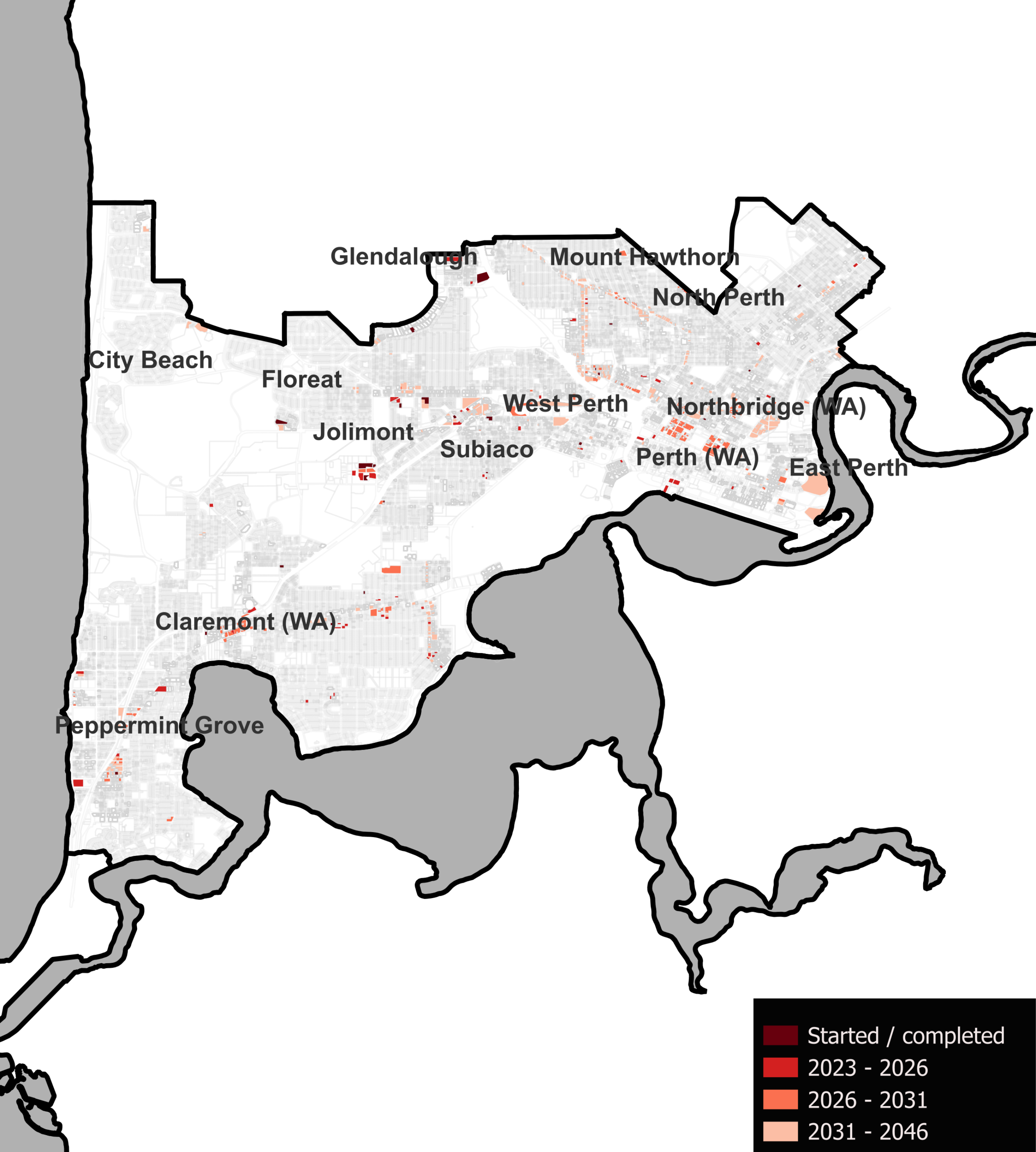
Map of development sites
The map below identifies all major development sites that have been identified in our research.
These sites have been organised to understand the likely location, capacity, timing and sequence of future development. By matching forecast population growth in this area to these sites, we can provide a more granular view of the distribution of the forecast population within a given region.
In the Perth - Inner region, we identified 460 development sites, 37.6% of these sites' capacity were used in the forecast period.
Learn more about our land use research →
1 national forecasting program.
6 ways to explore.
![]()
forecast.id
Plan for the changing needs of your community with a trusted forecast of population and housing in your Local Government Area, published in an accessible online tool.
![]()
forecast.id premium
Bring the full power of our National Forecasting Program into your organisation. We'll work with you to tailor a data partnership supported by briefings from our experts.
![]()
forecast.id partners
Our pay-per-download program gives our consulting partners instant access to reliable and respected forecast information on a project-by-project basis.
![]()
forecast.id hotspot report
Find a location near the people you serve with a tailored report that identifies up to ten locations with the highest number of people in your target demographic.
![]()
forecast.id location report
Whether you're investing in a new location or checking your current strategy is on track, forecast.id location reports quantify future demand around a known location.


.png?width=600&height=400&name=Meet%20the%20team%20%20Oliver%20Bowering%20(1).png)
