The population and housing forecast for the Bunbury region
Read forecast analysis and insights for the Greater Bunbury region from Australia's largest independent population forecasting team.
Detailed forecasts are available for this region
Our premium services give you detailed forecast information for this region to help you invest in the right place, at the right time.
- Forecasts by age and sex
- Single-year forecast periods
- Custom local area geography
- Forecasts of housing and development
Menu
Read the insights and analysis behind our population and dwellings forecasts for the Bunbury region.
About the Bunbury region
Bunbury is a region in Western Australia’s South West. It includes:
- The Shires of Waroona, Harvey, Collie, Dardanup, Capel, Donnybrook-Balingup, Boyup Brook, Bridgetown-Greenbushes, Manjimup, Nannup, Augusta Margaret River, and the Cities of Busselton and Bunbury
- The friendly bottlenose dolphins and vibrant art scene of Bunbury city
- Busselton Jetty - the longest wooden jetty in the Southern Hemisphere
- The vineyards of the Margaret River region
Key findings
A region with strong population growth across multiple (primarily coastal) fronts
The story of population growth in the Bunbury SA4 is not one of any single town - there are several key growth fronts in the greater region.
Proportionally, the largest population growth is expected in the Dardanup SA2: quadrupling the population to reach upwards of 10,000 residents by 2046 will primarily be driven by the planned Wanju development, which we forecast to begin accepting residents in the later part of the forecast period (2036 onwards) as land development opportunities dry up in Bunbury city. In the immediate term, Australind - Leschenault SA2 will accept the bulk of the population spillover from Bunbury, adding almost 4,000 residents in 10 years from 2021. It will be followed by Dalyellup SA2 in the medium term, with several development sites in the area being underway and potential for several more to emerge soon according to current zoning provisions - predicted to add over 4,500 residents in 2026-2036.
In absolute terms, the largest population growth is predicted further down the coast, in and around Busselton city - an extra 25,737 residents expected by 2046 across the SA2s of Busselton East and Busselton West collectively. There are a number of large areas (tens to hundreds of hectares) with development potential particularly further inland of Busselton expected to be of immediate developer interest off the back of the strong growth this region has already received.
Other areas of population growth expected in the Bunbury SA4 lie closer to the biodiverse south-western tip of the continent. Margaret River SA2 is set to continue its steady population growth in and around the main town as interest remains strong from young and older families and retirees. Nearby, the small towns of Witchcliffe and Cowaramup (both in Augusta SA2) are expected to continue adding population particularly in the earlier part of the forecast period, driven by several estates under construction and/or with plans for commencement in the near future.
On the flip side, several SA2 regions are predicted to accommodate only modest population growth during the forecast period. SA2s of College Grove - Carey Park, and Gelorup - Stratham, are restricted by very limited vacant residential land. On the other hand, regional inland townships are likely to not present the same level of pull as do the coastal towns, as evidenced by historical trends.
What share of Australia's growth will occur in Bunbury?
Read our forecast results and analysis for Western Australia to learn more about how the different drivers of population change affect the distribution of growth throughout the state.
Forecast results
The following forecast information is for the entire Bunbury region.
Learn more about the different options to access these forecasts for Local Government Areas (LGAs), suburbs, custom catchments or the entire state or nation here.
| 2026 | 2031 | 2036 | 2041 | 2046 | |
|---|---|---|---|---|---|
Forecast population |
213,283 |
230,102 |
246,328 |
262,821 |
279,122 |
Change (five year) |
18,289 |
16,819 |
16,225 |
16,494 |
16,301 |
Average annual change (%) |
1.8% |
1.5% |
1.4% |
1.3% |
1.2% |
Forecast dwellings |
95,218 |
102,682 |
110,263 |
118,060 |
125,918 |
Change (five year) |
5,430 |
7,464 |
7,581 |
7,798 |
7,858 |
Average annual change (%) |
1.2% |
1.5% |
1.4% |
1.4% |
1.3% |
Map of development sites
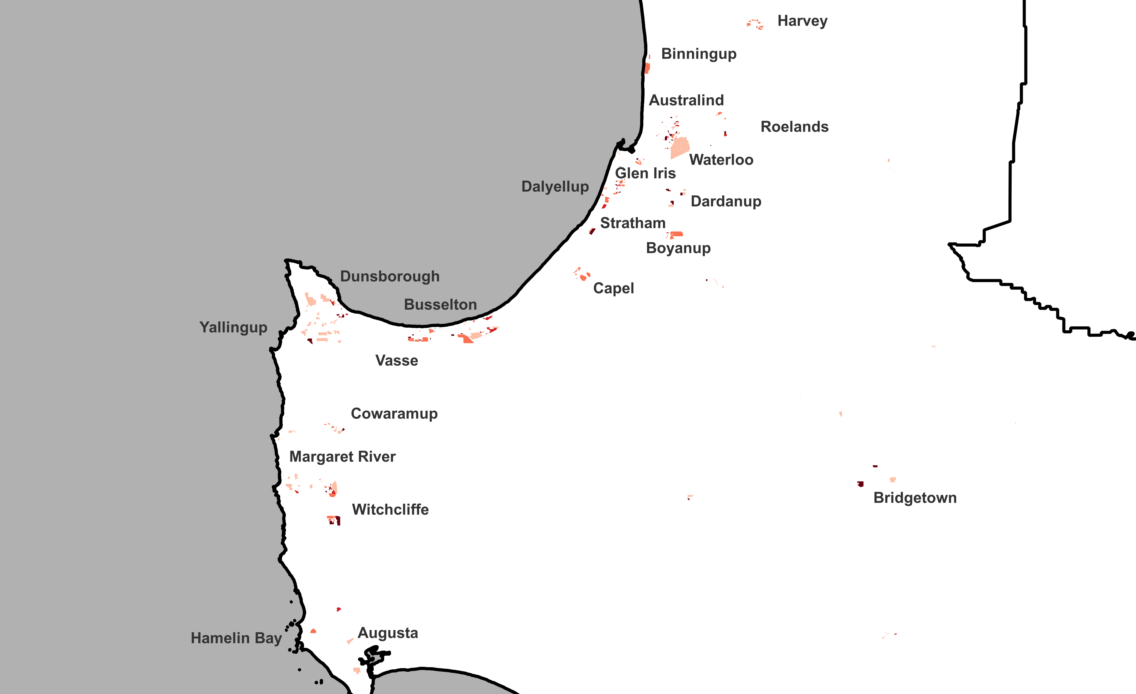
The map below identifies all major development sites that have been identified in our research.
These sites have been organised to understand the likely location, capacity, timing and sequence of future development. By matching forecast population growth in this area to these sites, we can provide a more granular view of the distribution of the forecast population within a given region.
In the Bunbury region, we identified 602 development sites. 57% of these sites' dwelling capacity was used in the forecast period.
Learn more about our land use research →

1 national forecasting program.
6 ways to explore.
![]()
forecast.id
Plan for the changing needs of your community with a trusted forecast of population and housing in your Local Government Area, published in an accessible online tool.
![]()
forecast.id premium
Bring the full power of our National Forecasting Program into your organisation. We'll work with you to tailor a data partnership supported by briefings from our experts.
![]()
forecast.id partners
Our pay-per-download program gives our consulting partners instant access to reliable and respected forecast information on a project-by-project basis.
![]()
forecast.id hotspot report
Find a location near the people you serve with a tailored report that identifies up to ten locations with the highest number of people in your target demographic.
![]()
forecast.id location report
Whether you're investing in a new location or checking your current strategy is on track, forecast.id location reports quantify future demand around a known location.


.png?width=600&height=400&name=Meet%20the%20team%20%20Oliver%20Bowering%20(1).png)
